Last updated: April 9, 2026
Author: Li Wei, Senior Geophysical Engineer, Inner Mongolia Exploration Project Team
Working in a grassland-covered area, we quickly realized that traditional methods alone wouldn't get us far. What changed the outcome for us was shifting to an integrated geophysical approach. By combining magnetic surveying and induced polarization, and relying on stable, high-precision instruments from Rancheng, we were able to see through the surface cover and identify mineralization that would otherwise remain hidden.
Working Through the Challenges of Covered Terrain
At the beginning, the biggest obstacle we faced was the thick grassland cover. It limited direct geological observation and made conventional exploration inefficient.
We tried approaching the area step by step, but it became clear that relying on a single method wouldn't deliver meaningful results. What worked for us was combining geological understanding with geophysical data and remote sensing insights. Once we aligned these together, the subsurface started to make much more sense.
Instead of choosing between methods, we combined magnetic surveys with induced polarization, which gave us both structural and mineralization information at the same time.

How We Carried Out the Geophysical Survey
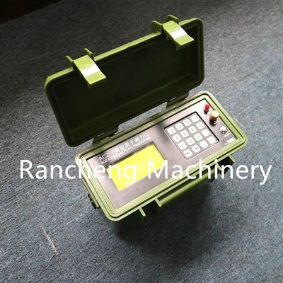
To get reliable results, we needed both precision and consistency in the field. We set up a survey grid with 100-meter spacing and carried out high-resolution magnetic measurements using the Rancheng ACZ-9 Proton Magnetometer.
Before and during the survey, we repeatedly checked and calibrated the instrument. We also performed data correction and repeat measurements to make sure what we were seeing was real and not noise.
For induced polarization, we used the Rancheng RC-7B system. Instead of applying a fixed setup, we adjusted parameters based on actual field conditions. That flexibility helped us keep the data stable and meaningful across the entire area.
What does the Data Mean?
Once the data came together, the results were clearer than we expected. In the southern part of the area, the magnetic anomalies aligned almost perfectly with aeromagnetic data, allowing us to trace structural features with confidence.
The IP results added another layer of understanding. We saw clear resistivity differences between rock units, and the anomaly trends matched the direction of known structures and alteration zones. One anomaly in particular, which we labeled DJ-1, stood out as a strong exploration target.
At that point, the subsurface picture was no longer fragmented-it started to connect.

Discovering the Orebodies
As we moved from interpretation to validation, the geological work confirmed what the geophysics suggested. We identified 19 orebodies in total, but only one was visible at the surface. The rest were completely hidden beneath the cover.
Most of these orebodies are hosted in structurally altered fracture zones, which explains why they were so difficult to detect using conventional methods. Among them, the No.1 and No.2 orebodies dominate in scale.
The No.1 orebody, in particular, showed stable characteristics and contained silver, copper, lead, and zinc. Its internal structure and element distribution were clear enough for us to consider it a high-value target for further development.

Going Deeper to Verify the Results
To make sure our interpretation held up at depth, we carried out induced polarization sounding along exploration line 61. Using the same Rancheng system, we collected multi-parameter data and pushed the investigation depth to around 500 meters.
When we compared the inversion results with geological sections, the match was convincing. The physical property contrasts we observed aligned well with known structures and mineralization zones.
This was a key moment-it confirmed that induced polarization wasn't just helpful on the surface, but also reliable for deeper exploration in this type of terrain.
What We Learned from This Project
1. Geophysical methods are essential in covered areas like grasslands, where direct observation is limited. Without them, most of the orebodies we found would likely remain undiscovered.
2. This type of polymetallic system does leave consistent geophysical signatures. Once we recognized the pattern-low positive magnetic anomalies combined with medium resistivity and high chargeability-it became much easier to target the right zones.
3. Combining magnetic and IP methods worked far better than using either one alone. Together, they gave us a more complete picture and reduced uncertainty in decision-making.
The Role of Rancheng Geophysical Instruments
The ACZ-9 Proton Magnetometer provided stable and precise magnetic data, while the RC-7B IP Instrument handled complex field conditions without compromising data quality.
With reliable instruments, we were able to focus more on interpretation and less on troubleshooting, which made the entire workflow more efficient.

By integrating geophysical methods, we were able to uncover hidden orebodies and establish a practical exploration model that can be applied in similar regions.
Throughout the process, stable and accurate field data made all the difference. The geophysical instruments we used-particularly the Rancheng ACZ-9 Proton Magnetometer and RC-7B IP system-performed reliably under complex conditions and supported every stage of our work, from data acquisition to final interpretation.
As we move into new projects, this combination of method and equipment will continue to guide how we explore and understand what lies beneath the surface.