


Product Description
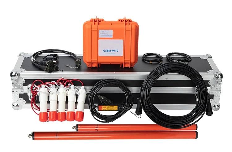
GSEM-W10 is an IoT-enabled broadband magnetotelluric system developed through more than two decades of research led by Associate Professor Chen Rujun from the School of Geosciences and Info-Physics, Central South University. Designed for environments with complex electromagnetic noise, the system can automatically recognize, separate, and suppress near-field interference, allowing stable acquisition of MT impedance data even in heavily disturbed conditions.
As a fully integrated geophysical survey instruments, the GSEM-W10 combines AMT and MT/LMT modes in one lightweight and low-power platform. It supports large-scale IoT networking of hundreds of instruments, increasing survey accuracy while lowering operational costs. AMT mode achieves a typical exploration depth of around 1,000 m, while MT mode reaches up to 150 km, meeting both shallow and deep exploration needs.
Technical Parameters
GSEM-W10(AMT)Geophysical Survey Instruments
1. Number of channels: 5(Ex,Ey,Hx,Hy,Hz);
2. Bandwidth: 1Hz~10kHz;
3. Gain: 0.1,1,3,9 optional;
4. GPS synchronization accuracy: 30 nS;
5. ADC bits: 32 bits;
6. Total dynamic range:160 dB;
7. Single power consumption: less than 2.5 W;
8. Sampling frequency: 150HZ/ 2400Hz/ 24000HZ;
9. Acquisition mode: 3 frequancy bands parallel acquisition, support real-time digital filtering;
10. Support Ethernet, WiFi measurement and control;
11. Support powerbank power supply
Working Principles
The system records natural electromagnetic variations in orthogonal directions to infer subsurface resistivity structure. Because natural EM signals are weak and easily disturbed, the GSEM-W10 geophysical survey instruments apply advanced circuit design, digital filtering, and wireless synchronization technologies to enhance data stability. In combination with the GSEM-PROS processing software-developed jointly with MT data specialists from the Russian Academy of Sciences-users can obtain impedance curves and quality-control outputs rapidly, even for large distributed arrays.

Key Features
Every stage of the analog front-end is engineered to preserve signal clarity-from differential sensing and precision calibration to layered filtering. This design keeps the instrument's noise floor at a very low level, ensuring that weak natural EM variations are captured with minimal distortion.
A streamlined ARM computing core and a modular Linux architecture keep the system's power draw far below typical MT instruments. Field teams can rely on a standard power bank for a full working day, reducing battery logistics and simplifying long-distance transport.
The GSEM-W10 geophysical survey instruments address interference from several directions at once. Hardware filters reduce mechanical and industrial noise, while adaptive and machine-learning algorithms automatically classify and suppress strong man-made signals. When multiple units are deployed as a wireless array, synchronized acquisition strengthens cross-station correlation, further pushing down uncorrelated noise.
Parallel multi-band acquisition shortens each station's recording time, enabling efficient coverage of long profiles or dense arrays. Wireless control via Wi-Fi and ZigBee allows a single operator to configure and monitor all units from a distance, and the processing software's multi-core design cuts impedance calculation time to a small fraction of conventional workflows.
A multi-layer PCB layout and optimized housing reduce overall instrument volume. Since the system accepts external power banks, transport is simple and air travel becomes easier without specialized batteries.

Application
For customers in mineral exploration, energy research, engineering assessment, or groundwater studies, the GSEM-W10 geophysical survey instruments provide a way to collect dependable subsurface information even in locations where electrical noise is usually a barrier. Mining companies can use it to map concealed orebodies beneath cover or within complex structural zones. Energy teams benefit from its depth range when evaluating basin architecture or fault systems. Engineering and environmental users gain a practical tool for locating weak zones, cavities, or fluid pathways without heavy field logistics. Because the system supports IoT networking and lightweight deployment, survey projects can be completed with smaller crews, tighter schedules, and reduced operating costs-all while maintaining consistent data quality.
Case Study: AMT Survey in Zhugongtang, Guizhou
In a survey at the Zhugongtang large lead–zinc deposit, a 1,280 m AMT profile with 61 stations (20 m spacing, 1–10,400 Hz) was completed using GSEM-W10 geophysical survey instruments. The final resistivity section clearly outlined gradient zones and a low-resistivity feature that marked favorable mineralization. These anomalies correspond well with the known orebody geometry and location, confirming that the GSEM-W10 geophysical survey instruments can resolve key structural and lithological features required in metallic mineral surveys.

Hot Tags: geophysical survey instruments, China geophysical survey instruments manufacturers, suppliers, factory, electromagnetic sweeper, electromagnetic field measuring device, electromagnetic hoist, electromagnetic vibration table, electromagnetic dust collector, electromagnetic tracking device


