As mineral resource development continues to move toward deeper layers and urban underground space utilization becomes increasingly complex, the demand for understanding subsurface conditions is growing rapidly. Whether it is mineral exploration, oil and gas reservoir detection, groundwater investigation, underground pipeline mapping, land subsidence monitoring, or geological hazard assessment, all rely on geophysical exploration technologies.
Geophysical exploration has become a key tool for "seeing into the Earth" without large-scale excavation.
What Is Geophysical Exploration?
Geophysical exploration is a method of studying subsurface structures by using differences in physical properties between underground materials and analyzing variations in geophysical fields.
Different rocks, ore bodies, groundwater, and artificial structures vary in density, magnetism, electrical resistivity, seismic wave velocity, and radioactivity. These differences allow geophysical instruments to detect anomalies and interpret underground structures through data processing and modeling.
Compared with traditional drilling and excavation, geophysical exploration offers wide coverage, high efficiency, relatively low cost, and minimal environmental impact. It is widely used in mineral exploration, oil and gas exploration, hydrogeology, engineering geology, and urban safety management.
Common Geophysical Exploration Methods
Gravity Survey
Gravity survey uses differences in density between underground rocks and ore bodies to detect variations in the gravitational field.
When high-density ore bodies, fault structures, or underground voids exist, they cause subtle changes in gravity values. High-precision gravimeters are used to measure these anomalies and infer subsurface structures.
Gravity surveys are commonly used in regional geological mapping, mineral resource exploration, basin studies, and underground void detection.
Magnetic Survey
Magnetic survey is based on detecting anomalies in the Earth's magnetic field caused by magnetic properties of rocks and minerals.
Iron ore and magnetite deposits can significantly affect the magnetic field, forming detectable anomalies. By analyzing these anomalies, the location and distribution of ore bodies and geological structures can be determined.
Due to its high efficiency and relatively low cost, magnetic survey is widely used in mineral exploration and geological structure investigation.
Electrical Survey
Electrical survey methods are based on differences in electrical conductivity of subsurface materials.
Rocks, soils, groundwater, and ore bodies have different resistivity characteristics. By injecting current into the ground or measuring natural electromagnetic fields, underground structures can be interpreted.
Common electrical methods include high-density resistivity, induced polarization, transient electromagnetic methods, and magnetotellurics.
Electrical surveys are widely used in groundwater exploration, mineral prospecting, geological hazard assessment, and engineering investigations.
Seismic Survey
Seismic survey uses artificially generated seismic waves to study underground structures.
When seismic waves propagate through different rock layers, they are reflected and refracted at boundaries. By collecting and analyzing these signals, subsurface geological structures can be reconstructed.
Seismic surveys are widely used in oil and gas exploration, tunnel engineering, infrastructure construction, and deep geological studies.
Radiometric Survey
Radiometric survey measures gamma radiation emitted from natural radioactive elements in rocks.
It is used to identify uranium deposits, rare earth elements, and specific rock types, and also serves as an important auxiliary method in regional geological mapping.
Borehole Logging
Borehole logging is a method of measuring physical properties inside drilled boreholes.
It includes resistivity logging, sonic logging, natural gamma logging, density logging, and other techniques.
Logging data provides key information about lithology, porosity, fractures, and fluid content, and is widely used in mineral, oil, and gas exploration.

Applications of Geophysical Exploration in Mineral Resource Exploration
As shallow mineral resources become increasingly scarce, exploration is gradually shifting toward deeper targets.
Traditional geological methods cannot directly obtain deep subsurface information, while geophysical exploration can penetrate hundreds to thousands of meters underground to detect structural and mineral anomalies.
For example, magnetotelluric methods can identify deep conductive zones, seismic methods can reveal deep structural activity, and high-precision gravity and magnetic surveys help delineate mineral prospecting areas.
By integrating geological, geochemical, and geophysical data, exploration efficiency can be significantly improved while reducing drilling risks and costs.
Applications of Geophysical Exploration in Oil and Gas Exploration
Modern oil and gas exploration relies heavily on geophysical technologies.
Three-dimensional seismic surveys provide high-resolution imaging of underground reservoirs, helping identify faults, traps, and reservoir distributions.
In complex environments such as deep basins, mountainous regions, and offshore areas, advanced seismic technologies and reservoir characterization methods greatly improve exploration success rates.
Geophysical methods are used throughout the entire oil and gas lifecycle, from exploration and development to production monitoring.
How Geophysical Exploration Protects Urban Underground Safety
Modern cities contain extensive underground infrastructure, including water pipelines, drainage systems, gas pipelines, power cables, communication networks, and subway tunnels.
Underground hazards such as cavities, leakage, corrosion, and ground subsidence may cause road collapse, pipeline failure, and serious safety accidents.
Underground Pipeline Detection
Electromagnetic detection methods are used to locate underground pipelines, determine their position, direction, and burial depth.
This helps prevent accidental damage during construction and ensures the safety of urban lifeline systems.
Underground Void and Sinkhole Detection
Ground penetrating radar, electrical methods, and microseismic techniques can detect voids, loose soil zones, and potential collapse hazards beneath roads and buildings.
Early detection allows preventive maintenance and reduces the risk of ground collapse.
Geotechnical and Engineering Investigation
Seismic and electrical methods are used to evaluate soil stability, determine bedrock depth, and analyze subsurface structures for engineering design and construction.
Land Subsidence Monitoring
InSAR (Interferometric Synthetic Aperture Radar) and precise leveling surveys are widely used to monitor land subsidence with millimeter-level accuracy.
These technologies help analyze subsidence causes, evaluate infrastructure risks, and support urban planning and disaster prevention.

Development Trends of Geophysical Exploration
With the rapid development of sensor technology, artificial intelligence, big data, and cloud computing, geophysical exploration is evolving toward more intelligent, high-resolution, and fully integrated systems.
Future exploration technologies will enable real-time data acquisition, automated anomaly detection, and multi-source data fusion, significantly improving exploration efficiency and interpretation accuracy.
Geophysical data will also be increasingly integrated with GIS, BIM, and digital twin technologies, supporting smart city development, infrastructure management, and sustainable resource utilization.
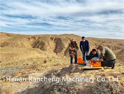
Rancheng Geophysical Equipment continues to provide reliable solutions for field exploration and data acquisition. Our product range includes electrical resistivity meters, mineral prospecting instruments, seismic survey systems, borehole logging equipment, and electromagnetic exploration devices, which are widely used in mineral exploration, engineering geology, groundwater detection, and urban underground investigation.
These instruments are designed to support accurate subsurface detection and efficient field operations, helping geophysical professionals achieve more reliable exploration results in complex environments.